.png?width=400&height=69&name=Namibia_Weather%20(4).png "Namibia Weather")
Frequently Asked Questions
Explore FAQs Below
↓

General Weather
What is the average temperature in Namibia?
Namibia experiences a wide range of temperatures depending on the region and season. Coastal areas like Swakopmund average 15°C-25°C (59°F-77°F) year-round due to the cold Benguela Current. Inland areas can reach 30°C-35°C (86°F-95°F) in summer (November-March) and drop to 5°C-15°C (41°F-59°F) in winter (May-August). The Namib Desert experiences extreme temperature variations, with daytime highs exceeding 40°C (104°F) and nighttime lows near freezing.
Does Namibia have a rainy season?
Yes, Namibia's rainy season typically runs from November to April, with peak rainfall in January and February. However, Namibia is one of the driest countries in Africa, with most regions receiving less than 400mm of annual rainfall. The northern regions like the Caprivi Strip receive the most rain (up to 600mm), while the Namib Desert and coastal areas receive almost none. Rain usually comes as afternoon thunderstorms that are brief but intense.
Why is the Namibian coast so foggy?
The Namibian coast experiences frequent fog due to the cold Benguela Current that flows northward from Antarctica. When warm, moisture-laden air from the interior meets this cold ocean current, condensation occurs, creating thick fog that can penetrate up to 50km inland. This fog is vital to the Namib Desert ecosystem, providing moisture to unique species like the fog-basking beetle and sustaining plants in one of the world's driest deserts. Fog is most common in the early morning hours.
What is Namibia's overall climate like?
Namibia is one of the driest countries in sub-Saharan Africa, with a predominantly arid to semi-arid climate characterised by high sunshine levels and low humidity. Average annual rainfall ranges between 250 and 370 mm, although this varies significantly by region. Large parts of the Namib Desert receive less than 50 mm of rain per year.
The country’s climate is shaped by the South Atlantic High-pressure system and the cold Benguela Current, which suppress rainfall and keep coastal areas exceptionally dry and cool. Inland regions experience hot summers and mild, dry winters, with pronounced temperature differences between day and night. Altitude and distance from the ocean create strong regional contrasts, making Namibia one of the most climatically diverse arid countries in Africa.
Does Namibia have distinct seasons?
Yes. Namibia has two primary seasons: a long dry season from May to October and a summer rainy season from November to April.
The dry season coincides with the Southern Hemisphere winter and is marked by clear skies, cool nights, and virtually no rain. Days are mild (20°C–25°C), while nights and early mornings can be cold, especially in the desert and highlands.These conditions are ideal for wildlife viewing, particularly in Etosha National Park, as animals gather around permanent water sources.
The rainy season brings higher temperatures and sporadic, short-lived afternoon or evening thunderstorms. Rainfall is highly localised and can vary considerably over short distances, but it transforms arid landscapes with fresh vegetation. The transition months of April/May and October/November are often especially pleasant for travel.
When is the hottest time of year in Namibia?
Peak heat in Namibia typically occurs from November to February, with January often being the hottest month overall. This pre-rainy transition period is known locally as the “suicide months” due to the intense build-up of heat before summer rains arrive.
During this time, inland temperatures frequently exceed 35°C (95°F) and can reach 40°C (104°F) in areas such as the Kalahari, Fish River Canyon region, and northern Namibia. Humidity remains low, intensifying heat stress. Coastal towns like Swakopmund, however, remain relatively cool and rarely exceed 25°C due to persistent maritime fog.
How cold does it get in Namibia during winter?
Winter nights from June to August can be extremely cold, particularly in desert and highland regions. Temperatures frequently drop to 0°C (32°F) or below in the desert and central highlands.
While daytime temperatures remain pleasant at around 20°C–25°C, clear skies and dry air allow heat to dissipate rapidly after sunset. Frost is common in the early mornings, especially around Windhoek, Sossusvlei, and towns such as Aus. Travellers should be well prepared for cold conditions during early-morning game drives and overnight desert stays.
Is Namibia windy?
Wind is a regular and influential feature of Namibia’s climate, especially along the Atlantic coast and during seasonal transitions. Strong afternoon winds are common in coastal towns such as Lüderitz and Walvis Bay, affecting sea conditions, fog formation, and perceived temperatures.
During winter, Berg Winds (also known as East Winds) blow hot, dry air from the inland plateau towards the coast. These winds can cause sudden temperature spikes, reduced visibility due to blowing sand, and elevated fire risk. In summer, consistent south-westerly winds along the coast make the region internationally renowned for windsurfing and high-speed sailing.
Inland areas are generally calmer but can experience gusty conditions ahead of thunderstorms. Wind also plays a key role in shaping Namibia’s iconic dune systems.
How many hours of sunshine does Namibia receive?
Namibia is one of the sunniest countries in the world, with most regions enjoying over 300 sunny days per year. On average, the country receives 8–10 hours of sunshine daily throughout the year, with some of the highest solar radiation levels recorded in the southern Namib Desert.
This abundance of sunshine supports Namibia’s strong solar energy potential and makes it ideal for outdoor travel and photography. Even during the rainy season, rainfall is typically brief and does not significantly reduce overall sunlight.
Does it ever snow in Namibia?
Snowfall in Namibia is extremely rare and highly localised. On exceptional occasions, light snow has been recorded on elevated terrain such as the Khomas Highlands and around the southern town of Aus.
Notable snowfall events occurred in 2011 and 2024, caused by intense cold fronts moving northwards from the Antarctic region. These events are short-lived, with snow usually melting within hours, and are considered meteorological curiosities rather than regular climatic features.
Does Namibia experience extreme weather events?
Extreme weather does occur in Namibia, but less frequently than in many other African countries. The most common extreme weather events are severe, multi-year droughts and sporadic, intense flash flooding.
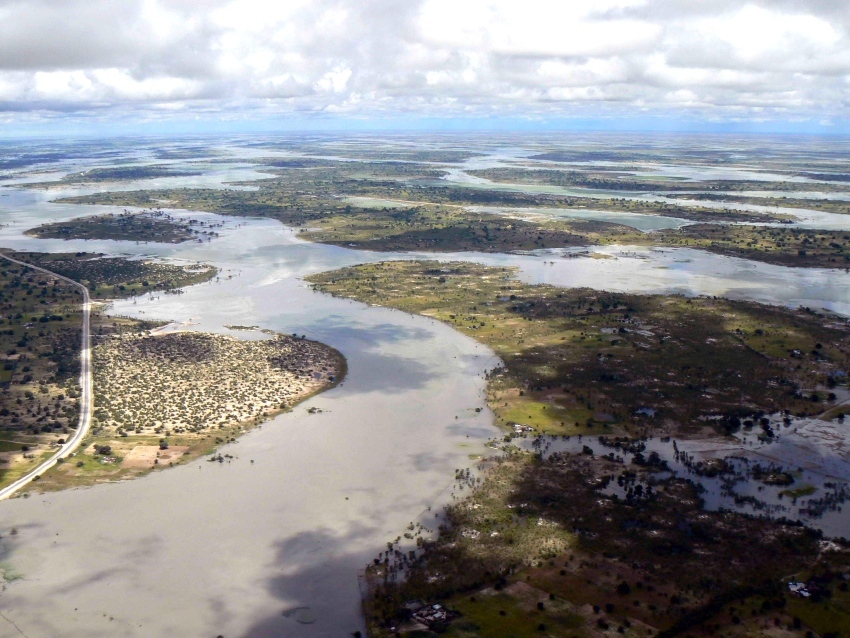
Northern regions, particularly the Cuvelai Basin, can experience seasonal flooding known as Efundja during years of heavy rainfall. These floods can disrupt communities but are vital for replenishing ecosystems. Conversely, multi-year droughts are a recurring feature and have significant impacts on agriculture, water resources, wildlife, and rural livelihoods.
Cyclones rarely affect Namibia directly, although remnants of tropical systems may bring unusual rainfall to the northeast. Flash flooding can occur in ephemeral river systems after heavy storms, and dust storms are a seasonal hazard in arid southern regions. Climate change is contributing to increased temperature extremes and more erratic rainfall patterns.
How accurate are Namibia weather forecasts in desert and remote areas?
Weather forecasts in Namibia are generally reliable for temperature and wind, but rainfall forecasts in desert and remote areas are less accurate, especially beyond 3–5 days.
When travelling in remote areas, check forecasts daily, remain flexible, and treat rain predictions as probability-based rather than certain.
What weather conditions affect 4x4 travel and road safety in Namibia?
The primary weather hazards for 4x4 travel in Namibia are flash floods in ephemeral rivers, deep sand softened by rain or heat, reduced visibility from dust storms, and sudden, severe temperature drops at night.
4x4 travel in Namibia requires planning for extreme conditions: never cross flooded rivers, deflate tires for sand and pack for both scorching days and freezing nights.
How does climate change impact rainfall patterns and drought cycles in Namibia?
Climate change is making Namibia’s rainfall more erratic and less reliable, with longer, more frequent droughts punctuated by shorter but more intense rainfall events, increasing pressure on water resources, agriculture, and ecosystems.
Climate change is not simply making Namibia drier or wetter, it is making rainfall less predictable, droughts longer, and extreme events more intense, reinforcing Namibia’s status as one of the most climate-vulnerable countries in sub-Saharan Africa.
Climate Zones
What are Namibia's main climate zones?
Namibia has four main climate zones: 1. Namib Desert (Coastal) - Cool, arid with frequent fog and minimal rainfall. 2. Central Plateau - Semi-arid with hot summers (30°C-35°C) and mild winters (15°C-20°C), includes Windhoek. 3. Kalahari Desert (East) - Hot and dry with summer rainfall, temperatures can exceed 40°C. 4. Northern Regions - Sub-tropical with higher rainfall (400-600mm annually) and warmer temperatures year-round. Each zone has distinct weather patterns influenced by altitude, latitude, and ocean currents.
How does altitude affect Namibia's weather?
Altitude significantly impacts Namibia's temperatures. The Central Plateau, including Windhoek at 1,700m elevation, experiences milder temperatures than lowland areas despite being inland. For every 100m increase in altitude, temperatures drop by approximately 0.6°C. This means highland areas like the Khomas Hochland can be 10-15°C cooler than the coastal plains. Higher elevations also receive more rainfall and experience greater temperature fluctuations between day and night, with winter nights occasionally dropping below freezing.
How many climate zones does Namibia have?
Namibia has four main climate zones: desert, semi-desert, savanna, and subtropical, defined by a dramatic rainfall gradient from the arid west to the wetter northeast. These zones are shaped by altitude and proximity to the Atlantic Ocean.
From west to east, Namibia transitions from the hyper-arid Namib Desert, through the semi-arid Central Plateau, into the Kalahari savanna, and finally the subtropical Zambezi Region in the far northeast. This gradient is shaped by three key factors: the rain-blocking influence of the cold Benguela Current in the west, increasing continental influence eastward, and higher altitudes on the Central Plateau which slightly increase rainfall. Each zone supports vastly different ecosystems, from fog-dependent desert life to lush, river-fed woodlands.
What is the climate of the Namib Desert?
The Namib is a hyper-arid desert, one of the oldest and driest on Earth, characterised by extreme temperature shifts and almost no rain, relying instead on coastal fog for moisture.
Rainfall is erratic and minimal, often below 50 mm per year and sometimes absent for years. In areas like Sossusvlei, summer daytime temperatures can exceed 45°C (113°F), while winter nights frequently drop below freezing. The most reliable source of moisture is not rain, but the dense coastal fog driven inland by the cold Benguela Current. This fog sustains a unique ecosystem, including ancient Welwitschia plants and fog-basking beetles, making the Namib a desert defined by oceanic influence rather than just aridity.
Why is the Skeleton Coast so foggy?
The Skeleton Coast’s persistent fog is caused by the collision of the cold Benguela Current with the hot, dry air of the Namib Desert. This cold ocean water chills the air above it, creating temperature inversions when warm desert air moves seaward.
When this cool, moisture-laden marine air meets the warm desert air moving seaward, it condenses into a thick fog that can blanket the coast and penetrate up to 50 km inland. This fog is a vital ecological resource, providing essential water to plants and animals in an otherwise rainless environment. It is most frequent in the early morning and is a defining, predictable feature of the climate for the entire coastal strip from Lüderitz to the Angolan border.
How does the Kalahari climate differ from the Namib Desert?
The Kalahari is a semi-arid sandy savanna, not a true desert, sometimes referred to as a “fossil desert.” The Kalahari has more vegetation, and even greater daily temperature extremes than the Namib.
While both are arid, the Kalahari receives significantly more rain averaging 150 to 250 mm annually in the form of summer thunderstorms, supporting grasses and Acacia trees on its iconic red dunes.
The key difference is the temperature swing: due to its continental location and clear skies, the Kalahari experiences some of the world's most dramatic diurnal ranges. A summer afternoon can be above 40°C (104°F), while the following night can drop near freezing. This contrasts with the Namib, where the coastal influence moderates temperatures, especially at night.
What is the climate of the Zambezi Region (formerly Caprivi)?
The Zambezi Region has a distinct subtropical climate, with high humidity, abundant rainfall, and major river systems, making it ecologically different from the rest of arid Namibia.
Receiving up to 700mm of rain annually this region is a maze of rivers (Zambezi, Chobe, Kwando) and lush floodplains. It is the only part of Namibia where malaria is a high risk during the humid summer months. The Zambezi Region receives the highest rainfall in Namibia.
The Zambezi Region's proximity to major river systems and higher annual rainfall creates a subtropical, wetland-influenced climate starkly different from the rest of Namibia. Receiving 600-700mm of rain annually with higher year-round humidity, this region supports lush woodlands, riverine forests, and expansive floodplains. Its weather patterns, including earlier and later rains, are more akin to neighbouring Botswana and Zambia, making it a prime birding destination, especially from March to April.
How does altitude affect Namibia’s climate?
Altitude has a significant moderating effect on Namibia’s climate. Higher altitude lowers temperatures, increases rainfall and creates cooler microclimates, most notably on the Central Plateau.
For every 100-meter increase in elevation, temperatures drop by approximately 0.6°C. This is why the Central Plateau (including Windhoek at 1,700m) has milder summers and colder winters than the surrounding lowlands. Mountains like the Khomas Hochland and the Erongo range force moist air to rise, cool, and condense, resulting in "orographic" rainfall that makes these highlands greener. Consequently, altitude creates dramatic climatic transitions over short distances, such as the cooler, frost-prone highlands versus the warmer, arid basins below.
What is the "Fish River Canyon" microclimate?
The Fish River Canyon has an extreme microclimate caused by its depth and geology. The canyon floor creates a severe heat trap, with temperatures often 5°C–10°C higher than on the rim, necessitating seasonal closures of the hiking trail for safety.
The deep gorge of the Fish River Canyon, one of the lowest points in Namibia, acts as a natural oven. During summer, dark rock surfaces absorb and radiate heat, and limited air circulation allows temperatures at the canyon floor to exceed 50°C (122°F), creating life-threatening conditions. As a result, hiking in the Fish River Canyon is only permitted from 1 May to 15 September. Even during this period, hikers must prepare for intense heat, carry sufficient water, and understand that there are no escape routes once committed to the trail.
Is climate change shifting Namibia’s climate zones?
Yes, climate change is intensifying aridity, causing a trend of "desertification" where semi-arid zones become drier and weather patterns become more variable and extreme. Observations indicate that the rainy season is starting later, becoming shorter, and producing more intense but less frequent rainfall events.
Rising temperatures are increasing evaporation rates, meaning that moisture disappears more quickly even when rainfall occurs. Other observable impacts include more frequent and intense heatwaves.
These trends are gradually shifting semi-arid savanna regions towards more desert-like conditions, with significant implications for agriculture, biodiversity, and water security. Prolonged droughts are becoming more common, significantly affecting both wildlife in national parks and livelihoods in rural communities.
What is the weather like in Swakopmund and Walvis Bay?
These coastal towns have a cool desert-coastal climate with stable temperatures. The weather is moderated by the ocean, with frequent fog, strong afternoon winds, and temperatures rarely exceeding 25°C.
The cold Benguela Current keeps these towns cool and often overcast, even when inland Namibia experiences extreme heat. Mornings are often cool and foggy, with strong south-westerly winds developing in the afternoon. This creates a natural "air-conditioning" effect, making the coast a popular summer retreat. However, during winter Berg Wind events, temperatures can rise sharply for short periods, occasionally making the coast temporarily hotter than the interior.
Best Time to Visit
When is the best time to visit Namibia for weather?
The best time to visit Namibia for pleasant weather is during the dry winter months from May to October. During this period, temperatures are mild (20°C-25°C during the day), skies are clear, and humidity is low. June to August offers the coolest temperatures, ideal for hiking and outdoor activities, though nights can be cold (near 0°C). September and October are warmer but still comfortable. The rainy season (November-April) brings higher temperatures and occasional afternoon storms, but also transforms the desert with blooming flowers and lush vegetation.
What should I pack for Namibia's weather?
Pack for layering as Namibia experiences significant temperature variations. Essential items include: Lightweight, breathable clothing for hot days, warm jacket or fleece for cool mornings and evenings (especially May-August), sun protection (hat, sunglasses, SPF 50+ sunscreen), closed walking shoes for desert terrain, and a light rain jacket if visiting November-March. Coastal areas like Swakopmund require warmer layers year-round due to fog and wind. Neutral colors are best for wildlife viewing areas.
Is Namibia's summer too hot for travel?
Summer (November-March) can be hot, with temperatures reaching 35°C-40°C (95°F-104°F) in many areas, but it's not prohibitively hot for travel if you plan accordingly. Travel early morning or late afternoon, stay hydrated, and seek shade during peak heat (12pm-3pm). Summer advantages include: fewer tourists, lower prices, dramatic thunderstorm skies for photography, newborn animals, and green landscapes after rains. The coastal areas remain cooler (20°C-25°C) year-round. If you handle heat well, summer can be a rewarding time to visit Namibia.
When is the best time to visit Namibia?
Namibia can be visited throughout the year, each season offering something unique. The dry season (May to October) is ideal for wildlife viewing, as animals gather around water sources and visibility is excellent, with mild temperatures and clear skies. The wetter summer months (November to April) bring warmer weather and rainfall, mainly in the north and east. The rainy season transforms the landscape into lush green scenery, attracts migratory birdlife, and is a prime time for photography and witnessing newborn animals.
Is Namibia a good year-round destination?
Yes. Namibia is a year-round travel destination, with each season offering a distinct experience, from prime wildlife viewing and dramatic desert landscapes in winter to green scenery, birdlife, and striking skies in summer.
What is the best time to visit Namibia for wildlife and safaris?
Winter: May, June, July (August it can rain already). With limited water sources, animals gather around rivers and waterholes, particularly in Etosha National Park, offering exceptional game viewing opportunities.
What is Namibia like in summer (November–April)?
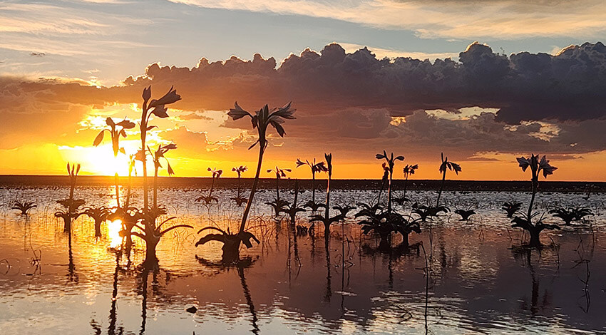
November, Dezember, and January are very hot, with seasonal rainfall, particularly in the north and east, that transforms the landscape into lush, green scenery. This season is ideal for photography, birdwatching, and scenic travel, although wildlife can be more dispersed due to increased water availability.
What is Namibia like in winter (May–September)?
Winter is dry, sunny, and mild during the day, with cooler to very cold mornings and evenings. These months are perfect for safaris, hiking, and exploring Namibia’s iconic landscapes, offering comfortable travel conditions and high wildlife concentrations.
When is the peak safari season in Namibia?
Namibia’s peak safari season runs from June to October, when dry conditions make wildlife easier to spot, especially at waterholes in Etosha National Park and along perennial river systems in the north.
When is the best time for birdwatching in Namibia?
Birdwatching is especially rewarding during the summer months (November to March), when migratory species arrive, wetlands fill, and savannah areas become highly active, particularly in the Zambezi region
Are there any months to avoid visiting Namibia?
There are no months that should be avoided entirely. However, January to March can be very hot, and heavy rainfall in the north-east may occasionally affect travel routes. These months are best suited to travellers who enjoy quieter destinations, seasonal contrasts, and dramatic landscapes.
When is the best time to visit Namibia for photography?
The best time for photography depends on the subject.
-
Winter (May–September) brings clear skies, golden light, and dust-free conditions, perfect for wildlife photography in national parks like Etosha.
-
Summer (November–April) delivers lush landscapes, dramatic cloud formations, and vibrant colours, ideal for landscape and nature photography.
“When is the best time to visit Namibia based on weather by region?”
(Coast vs Desert vs North vs Zambezi — practical travel planning intent)