Namibia Weather
logo-black
  • Home
  • Weather Summary
  • Webcams
  • Forecast & Advisories
    • 24hr Rainfall Forecast
  • Satellite Images & Charts
    • Wind Map
    • Wave Map
    • Static Images
    • Synoptic Charts
    • Sea Surface Temperature
    • El Nino Southern Oscillation
  • Maps and Radar
    • Wind and Forecast Map
    • Flight Radar
    • Marine Radars
  • About
    • About Namibia Weather Network
    • Join the network
    • Instrumentation Used
    • Contact
  • Links
    • Useful Weather Links
      • Kobus Botha - Weather
    • Namibia Links
      • Gondwana Collection Namibia
      • Klein-Aus Vista
      • Book a trip to Namibia
      • Namibia2GO
      • Site Map


South Atlantic Ocean Surf Forecast

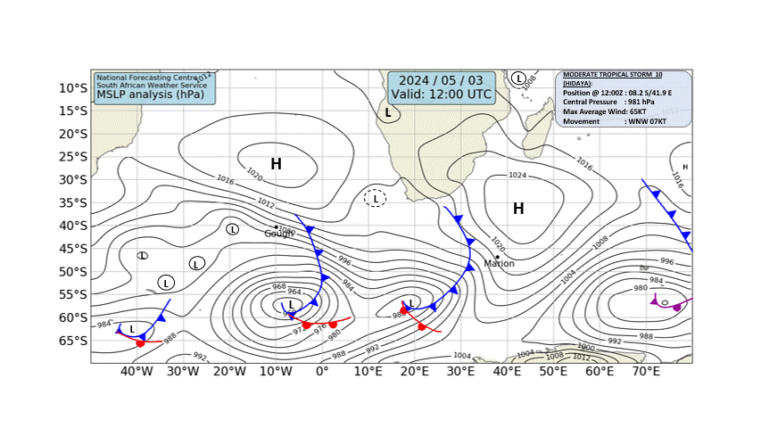
The images in this surf forecast depict the expected state of the atmosphere and Sourth Atlantic Ocean 24 hours from today.   Data is obtained from various atmospheric models and wave models.   Use it to determine if waves and wind conditions will be favorable for your beach.

Mean Sea Level Pressure From MRF Model
Courtesy: South African Weather Service


South Atlantic Ocean Surf Forecast


Namibia Weather - Powered by Gondwana
Top Contact Us Bookmark Page (CTRL-D) User Agreement Privacy Policy

Follow us

Use of this site signifies your acceptance of the User Agreement and Privacy Policy.

Never base important decisions on this or any weather information obtained from the Internet.

© 2025. Namibia Weather Network | Valid XHTML 1.0 | Valid CSS
Copyright 2025. All Rights Reserved by Gondwana Collection.

SATELLITE IMAGES & CHARTS

Wind Map Wave Map Static Images Synoptic Charts Sea Surface Temperature El Nino Southern Oscillation

WEATHER INFORMATION

About Namibia Weather Network Instrumentation Used Weather Summary Site Map Wind and Forecast Map Flight Radar Marine Radars Webcams

POPULAR LOCATIONS

Swakopmund Aranos (Farm Skemerhoek) Kwessi Dunes (Namibrand) Namib Desert Lodge Sossusvlei (Namib Sky Balloon) FishRiver Canyon Roadhouse Sesriem Palmwag Omuthia (King Nehale Lodge) Ngoma (Chobe River Camp)